Saturday, September 20, 2014

Pink Lemonade


We all know the old saying about making lemonade with “lemons” – here in Puna we take that a step further, using the invasive guava trees to make “pink” lemonade.  You will sometimes see locals alongside the roads picking both pink and yellow guava – from the top heavy branches.  Only problem is that everything here tends to grow to t-a-l-l so fast, you can’t easily reach them. 

Believe it or not, our dogs LOVE the guavas – but then again, they also love carrots, bok choy and cabbage!  We have several guava trees along the driveway, so walking down to get the mail, it’s always a dash between me and the three corgi dogs to see who can get to the newly fallen ripe ones first.  I always let them have a few.

When we first moved in a couple years ago, I decided to try an experiment with one of the too-tall-trees and cut it off 12 inches from the ground to see what would happen.  Lucky me!  It has grown into a guava “bush” instead, only 5 feet tall with branches loaded with pink guava.  Now that I know that works, I’ll do the same with the rest of them.

Friday, September 19, 2014

Island of PUNA?!


USGS Photo taken June 27, 2014
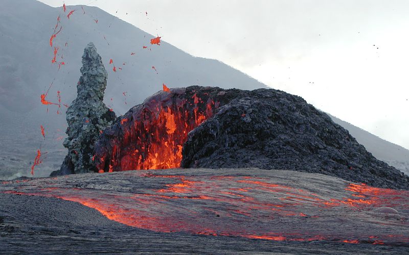
This is a photo of Pu'u O'o on June 27th -- the day the NE flow began.  As of September 18th,  according to Hawaiian Volcano Observatory, the leading edge of the lava flow is 300-500 feet wide and 1-2 feet thick. It can thicken, however, to 10 feet or higher as it builds upon itself.  Because the flow does vary, it is difficult to project the exact date that the lava will reach Pahoa and Hwy 130. Given the most recent average daily flow, HVO projects that the lava will reach Pahoa Village road around the end of the month, and Highway 130 around mid-October. *** These dates are estimate each day, based on flow activity and are updated by USGS. ***    From there it is only 4-5 miles to the ocean.


 "The Island of Puna" - home of the Punatics

The black X indicates the area of flow for the past 30 years down through Royal Gardens and Kalapana to the ocean; it is now many miles wide and impassible.  The BLUE lines indicates an old railroad path (not even a real road) and a beach road that is barely passable for most cars.  The county is going to open these temporarily for general traffic.  But the reality is there is nothing to stop the lava flow RED lines as it heads towards downhill to the ocean.  Very soon even those temporary roads will not be accessible.

The GREEN circle represents thousands of people who may will be living on The Island of Puna. (PS: One blog reader had an estimate of 8500 -- but we all know there's probably even MORE.)


Thursday, September 18, 2014

Retired and REWIRED!


RETIRED AND REWIRED

Last August 2013 as we were finishing up building the ohana, we had a conversation with our contractor about eventually wanting to do an electrical wiring that would, in an emergency, allow us to utilize our generator most efficiently.  The reason I know this is because I wrote it down in our “bible.”  Now our “bible” is a reference book with categories and information about such Puna Topics as:  Bugs & Pests, Water Pump, Gutters (the cleanout debris schedule, which if we forget, clogs up with leaves), Propane (where to get it at what prices, and when we refilled our tanks), etc, etc.,  Since living here necessitates learning new skills and language associated with those skills, it has taken on the hallowed essence of "The Sacred Word of Life In Puna."


We are using our skilled contractor for this rewiring work, but we have to understand what he has done, and what steps we need to do when the power goes, how to switch the generator on, and switch on related systems like the water pump from solar to generator/12volt, etc.  Now we have dedicated lines for refrigerator, freezer, computer, phone and TV, as well as lines for the tenants in our ohana for their refrigerator and kitchen.  While we had it written down and knew it was important, The Lava Event has made it a high priority.  Mahalo to our Leilani friend Richard who gave us a personal tour of his own “smart house” to begin our power-full education.  All that’s left now is to finish the little generator shed and we have checked off another thing on our self-sufficiency list.  (Just wait ‘till you see the too cute shed.)


Tuesday, September 16, 2014

Pantry Done (check!) Dog Food (check!)

Day by day the checklist of "things to do" is getting done.  Hurricane Iselle was actually a good test run for some of our emergency preparedness systems, including use of solar panels and 12volt battery system to run the water pump and filtration during the days without electricity.  And, we got a good test drive with our generator too.  Hurricanes, however, come and go....and,

....preparing for a Lava Event is different.  In some ways it is simplified by the horror of it heading right at your house:  you get OUT fast!  But when it is slowly headed toward your only highway in an out, things take on a different perspective. Water is not an issue, power is manageable, but what do you do about food when your local market closes because it is in the path of the advancing flow, and the highway is closed?  STOCK UP on non-perishables.

The freezer is full of salmon, chicken, lamb, roasts, catfish, bacon, nuts, goat, cheddar and Havarti cheeses, breads and muffins.  After a mega-shopping spree in Hilo last week, this week it was time to sort, organize and label the pantry items.  We feel we could actually manage well on what we have for 5-6 weeks.

OF COURSE the pantry is well stocked with dog food!!
We have a neighbor on our street who launches down at Pohoiki (where I swim) and catches fish weekly -- yum!  We can depend on some "portable" local farmers' markets to provide us with fresh items weekly.

 This week with the help of our contractor, we will have our sub-panel system installed next to our electrical box; this system allows us to easily "switch" from electric to generator.  This week we also finish construction an insulated generator shed -- out 20 feet from the house to reduce both noise and exhaust.(check!  check!  check!)   As you may have guessed, plans for assembly and installation of the hot tub have taken a back seat to these priorities, but soon we will be doing that as well -- by then we will need it!)


Monday, September 15, 2014

Fire in the Sky

Late today after working to organize our pantry's big influx of food, we went down to Pohoiki for the sunset and so I could take a swim in the ocean.  This weekend the surf was very high, and it was a thrill just to watch the surfers on extra big waves -- while staying close to shore.  Blowing out over the ocean was a hazy layer of brownish pink cloud -- smoke from the fire, ash and volcanic gases. (Not currently at our house.)

Simulation of two colliding galaxies.

We've been so focused on looking at the ground, volcanic flow, gravity specific topo maps and such, when we got an email from a neighbor about the "glow" from the flow behind Pahoa, it was distraction to go outside on a deep dark (no moon) night to take in the sky.  From our house it is actually a very soft smudge.  On the other hand, the Milky Way was STUNNING.

www.capitalbay.com  PHOTOS

At our house, it is arcing across the sky like a shimmering scarf of diamond dust -- in an true North South orientation.  This has always perplexed me somehow as if I was seeing things sideways.  Then I remembered the recent entry Sept 4) about the discovery of our Galactic Cluster "Laniakea" where ribbons of galaxies enfold each other like a huge rose.  So, we are topsy-turvy so to speak, just hangin' out against a dark background (apologies to Iain Banks.)  Good to know our place in the scheme of things.

Saturday, September 13, 2014

Lava Heading toward Pahoa Village


This blog entry will be very short because we are very busy right now preparing for the coming two weeks.  While lava is no longer flowing directly at our subdivision, it is headed directly toward Pahoa Village, just a couple miles away.  This includes post office, banks, gas stations, markets, bookstore, eateries -- and our charming wooden sidewalks!  People are scrambling. The next piece of the puzzle is watching the lava flow across highway 130 -- our access to Hilo, Kona and the rest of the island.  People who live south of the flow, and work in Hilo are all scrambling to relocate fast. We are provisioned with food and water and supplies for 5-6 weeks.  Power outages can be handled for the time being with our generator.  There's more, but we have have work to do and will send details with an email to you in a couple days.

Friday, September 12, 2014

Pele Dreams

It is easy to get sideswiped by all the "activity" going on related to an imminent "lava event" here in Puna.  It is very real.  On the other hand, sometimes it is of value to simply sit down and think about the raw beauty and power being observed and our response to it.  Or better yet, participate with it as an experience experiment!

Today I went for a long luxurious swim in the ocean with my friend, Jan.  Swimming out farther than I had before, I could see surfers catching waves on deep blue water.  The water was warm, clear and inviting, so I laid on my back allowing the waves to undulated beneath me lifting me up to the rhythm of my breath.  I felt safe, calm, protected and connected.   While floating I wondered what Pele's dreams might look like, so I closed my eyes to imagine them.

I play with vivid colors and dynamic shapes to express my relationship with the world here -- of physicality and essence.  I juggle these ideas, shapes and colors in my abstracts until they coalesce and connect coherently to my inexpressible emotion. 

To be honest, I don't even know what I just said, or tried to say.  Maybe this new creation will help.  Part of me doesn't even want to give it a name; words being, despite my addiction to them, inadequate.  So how about a working title of...."Pele Dreams."

Wednesday, September 10, 2014

Puna Lava Flow


New altar arrangement; gifts for Pele
Lava Could Reach Pahoa Road by Sept. 24We are including an article (below) which tells the story well and factually.  Needless to say, we are taking this seriously.  Monday we found and bought a long-bed truck -- a Toyota Tundra which will keep us mobile.  We have our emergency plans as tidy as possible.  Although the flow appears (for now) to have turned away from Leilani Estates where we live, if the lava crosses our main highway 130, we could be cut off from supplies for weeks.  We have food and water for a few weeks, including dog food.  Our water pump can be switched from electric to solar powered 12volt battery, and the big generator that saw us through the hurricane is primed and ready to go with about 20 gallons of gas in reserve.  
 

LAVA COULD REACH PAHOA ROAD BY SEPT 27   
West Hawaii News - Nick Gaddis  (excerpts)

A lava breakout that began on June 27 along the northeast flank of Pu`u O`o could reach the Pahoa Government Road by Sept. 24 if it does not divert sooner, according to an information update released yesterday by the Hawaiian Volcano Observatory and the USGS.  The flow had been moving alternately between ground cracks and along the surface since Aug. 18 before reemerging on Sept. 6, and picking up speed.  Since reemerging, the flow has advanced at an average of 1,300 feet per day.  If the flow continues on its current track, HVO projects that lava could move through the northern section of Kaohe Homesteads, or slightly to the north of the residential area, reaching the government road in Pāhoa within 16-18 days.  This path could be disrupted or altered if the lava becomes further confined within the cracks and down-dropped blocks within the East Rift Zone of Kīlauea volcano.

HVO’s estimates will be continually refined as they track the lava flow’s activity. The Pu‘u ‘Ō‘ō vent in the East Rift Zone of Kīlauea Volcano began erupting on Jan. 3, 1983, and has continued erupting for more than 31 years, with the majority of lava flows advancing to the south.  Over the past two years, lava flows have issued from the vent toward the northeast. The June 27 flow is the most recent of these flows and the first to threaten a residential area since 2010-2011, according to HVO.

(see previous blog entries for map showing Hwy 130)


Friday, September 5, 2014

Mapping Obsession

This map shows our subdivision on right (football shape)
People living in PUNA these days are obsessed with maps!  Seems like everyone is looking for the "perfect map" -- you know, the one that will tell you that the lava will NOT be coming into your subdivision, will NOT be taking your home, your life savings, your kids and dogs, or your retirement.  And, perhaps like many folks, we have one on the kitchen table (photo shopped) with appropriate punctuation.
This is a detailed TOPO map on the kitchen table

Bottom Line:  No one really knows.  CNN had some good coverage today on the morning news, the mayor has declared a state of emergency and people living in the direct path are beginning to evacuate.  Predictions are flying.  Many based on educated guesses and scientific historical evidence, and some rooted in fear.  Most folks we know are working hard to maintain a healthy balance.

Phil and a friend went into Hilo the other day to check out storage units -- just in case.  Many people who live in our subdivision of are hoping that simple GRAVITY is the prime factor and if so, we may get lucky.  Who knows for sure?

The map with the squiggles was produced by the USGS in 2007.  It is based on the direction of STEEPEST flow.

Today, we mowed the yard, packed up the garbage and recyclables for the dump, and made egg salad sandwiches.  Life goes on.  For now, we're committed to enjoying every moment.

Our house is the tiny red dot near the right edge.


Someone created a map from info at hand as a possible "prediction" map that shows the flow going north and west of Leilani, but....oooops, right through poor Pahoa Village and crossing 130 thereabouts.  Not great either.  It's anyone's guess -- what Pele will do.


Thursday, September 4, 2014

Laniakea Super Cluster


Taking a necessary break from discussions about Puna lava flows, evacuations, predictions, civil defense strategies to focus on a new discovery...the bigger "home" we share.

Laniakea, described in the journal Nature, stretches some 500 million light years across and holds 100,000 galaxies with the mass of a hundred million billion suns.  This super cluster, scientists said, provides a whole new lens on the mysterious internal dynamics of such giant clusters, the biggest structures in the universe.

Laniakea is the galaxy supercluster that is home to the Milky Way, the Solar System and Earth. It was defined in September 2014, when a group of astronomers led by R. Brent Tully of the University of Hawaii published a new way of defining superclusters according to the relative velocities of galaxies.

The name Laniakea means "immeasurable heaven" in Hawaiian, from "lani" for 'heaven' and "akea" for 'spacious' or 'immeasurable'. The name was suggested by Nawa'a Napoleon, an associate professor of Hawaiian Language at Kapiolani Community College. The name honors Polynesian navigators who used heavenly knowledge to navigate the Pacific Ocean.

(Information was gleaned from a variety of sources including LA Times, Nature Magazine and Wikipedia.  I adapted a photograph to black and white for good contrast.)


Sunday, August 31, 2014

Elements III

Well, how could I NOT post this photo!  Phil just finished the frame for it using scrap 2x4 board from our lanai projects.  And who'da thunk it would have turned out so beautiful.  I just had to post it.  L


“ELEMENTS III”
By Lunel Haysmer

You cannot live on this island and not be aware of the elements that surround you:  Fire, water, wind, and land. Some are intimate and nurturing; some are violent and destructive.  Having just come through a hurricane and now watching lava flowing a few miles from our home, that awareness has pushed through the emotions and fear to produce art! 

This series called ELEMENTS expresses how I feel inside as I respond to these forces over which I have no control.  Some friends think we are crazy to have even moved here, but I know this is where I want to live and die – here on the edge of life in all its inspiring vitality.

The colorful images used in this art are ones I have been developing for the last year.  They are digitally modified original fractals I have manipulated.  They are overlaid with hundreds of pieces of broken automobile glass that have been tediously arranged and grouted in place.  The details of the process are my trade secret at this time while I continue to play with these “ingredients.”


Smoke In the Air

USGS webcam looking east (our subdivision is far left)
Since all the windows are open in the house, it is pretty easy to notice the smoke in the air.  Yesterday as we left Pahoa and drove into Hilo (to drop off Lunel's art at Hawaii Museum of Contemporary Art for the "Trash Show") there was a plume of smoke visible rising from the new flow area.  Today, the trade winds are minimal and the sun coming up through the trees is casting long feathery rays of light in a eerie elongated fan shapes across the yard.  The photo above was posted this morning by USGS and is a remote view of the lava as it inches its way through the forest.  (** See Update at bottom.)  It is not always visible when it submerges down into cracks and fissures.  Don't let that "tiny" spot of orange fool you.  There's over 16 acres of "visible" lava, and the rest is moving slowing either on the surface or down fissures as this next photo illustrates.


Aerial shot from opposite direction.

Yesterday morning, it was clear and crisp, however, and we found this delightful couple of lovey dove sitting on the rusted wheelbarrow out in the back orchard area.  In the foreground you can see pineapple and behind you can see the edge of the avocado tree.  Behind is typical forest/jungle.

For a while, Phil was tossing out a handful of seed in the morning, but within a few weeks, we were inundated with about three dozen doves who were crowding out many of the other frequent visitors, so we decided to stop the feeding.  The dove population is now back down to less than a dozen.

Sadly, during the hurricane crises, we missed harvesting a few pineapples that got overripe on their stems.  We did, however, save the tops and have them rooting in pots for replanting.  You can see some of the pineapple plants in the foreground with avocado and woods behind.

What an interesting juxtaposition -- the real threat of "what could happen" mixed with today's coffee, dismal world events, and making brownies for tomorrow's Labor Day Party with friends.

(P.S.  By the time I finish this entry and push "Publish Blog" -- the smoke has dissipated some, the dogs are stirring; I leave the unknown and unknowable behind; shall we have pancakes?) 

** Email report in from our terrific Civil Defense Warrior, Darryl, about the ground-level smoke)
"I just got back in from this morning’s over flight. There was s prominent inversion this morning holding the smoke conditions down near the surface and not allowing it to dissipate. The conditions should as was starting to improve with the heating up of the morning sun and the pickup of winds.  As for the flow, it is a very slow moving surface flow and is fairly narrow in width. The burning of vegetation remains limited to only what is being touched by the flow and there is no brush fire or wildland fire threat. The leading edge of the flow is approx. 1.3 miles from the Wao Kele Puna Forest Reserve and no immediate or imminent threat."